Bus, Trolleybus and Tram Routes of Kingston upon Hull Corporation, Predecessors and Successors. 1899 to 1986 - Chapter Twenty Seven
Bus, Trolleybus and Tram Routes of Kingston upon Hull Corporation
Predecessors and Successors. 1899 to 1986
Chapter Twenty Seven
Terminal Points
To state the obvious, most bus (or tram or trolleybus) routes usually have two terminal points. The first of these is usually situated in the centre of population, often at a specially designated bus station. The second being situated at the other end of the route, this is usually known as the outer terminal. Not all routes, however, radiate from a central location, and may have two outer terminal points, the route of which may or may not pass through a central area.
In Kingston upon Hull, the routes used by public transport vehicles were almost always radiating from the city centre. From October, 1935, most of these commenced fro the newly opened Coach Station, as it was called from the outset. There were very few routes which did not follow this pattern until the 1960’s. All the inner terminal points were located in the City centre, or within ˝ mile of it. In the period under study, 1909 to 1986, there are twenty six terminal points in this area. Historically, however, early bus services commenced from Bond Street, this being the pioneer bus route to Stoneferry. The reason being that it traversed a route proposed for a tramway extension; Bond Street being situated at the proposed junction with the existing tram routes. Other early bus routes commenced from Paragon Square, which at that time was adjacent to Brook Street. The Askew Avenue route commenced from Paragon Street, which was also the starting point for some EYMS services. Night and Sunday morning services commenced from Queen Victoria Square. The Fish Dock route was the only normal route to commence from this point; later some night services commenced from King Edward Street. During 1931, the southern end of Brook Street was extended through to Anlaby Road, and also northwards to the junction of Spring Bank, Beverley Road and Prospect Street, thus leaving a curtailed Brook Street between the new road and Prospect Street. The new road was given the name Ferensway, after Alderman Ferens. The services acquired from East Yorkshire to Sutton, also commenced from Ferensway, as did the night and Sunday morning services on route 21. The exact location of the termini is not known for certain. At this point of time most normal services commenced fro Paragon Square, however from 1933, new stands were introduces on Ferensway, and were located “north of the Corporation electricity showroom”, but again the exact location is unknown. All but two routes, these being the 15 and 39, were moved from Paragon Square to the new stands. The 15 and 39 already commenced from Ferensway. Night and Sunday morning services, however, remained at King Edward Street or Queen Victoria Square as previously, whilst the route 8 continued to commence from Paragon Street. Prior to co-ordination the layout of city centre termini, with routes, were as under:Ferensway Bus Stands: 11, 16, 30, 31, 32, 34*, 36*, 36*(Sutton Hospital), 38, 45 and 50; Paragon Square: 15* and 39: Paragon Street: 8; Queen Victoria Square: 1; Savile Street: 47.
Night Services termini: Ferensway Bus Stands: 21*; King Edward Street: 11, 15 and 22+; Queen Victoria Square: 3+, 8, 9+, 20+, 39, 45, 47+ and 50+.
Sunday Morning Services termini: King Edward Street: 15, 18 + and 21*; Queen Victoria Square: 8 and 39.
Codes: + denotes services run to replace tram routes on nights or Sunday mornings. *These services were withdrawn upon implementation of the co-ordination agreement.
After co-ordination, the following new bus services commenced operation: Ferensway Bus Stands: 12, 15, 20, 34, 35, 37, 39, 39A, 40 and 40A; King Edward Street: 19 and 42; (night services); 20, 22 and 41 (Sunday Morning services); Paragon Square: 21, 45A, 46 and 46A; Paragon Street: 3, 7 and 9; Queen Victoria Square: 34 and 46 (night services); 34, 45 and 46 (Sunday Morning services).
From October, 1935, the Corporation opened the Coach Station, which was situated between Collier Street and Lombard Street, and most routes had their terminals transferred there, and most new services also started from there also. In the early period, the city centre was the terminal point for all tramway services. Right at the start of municipal tramway operation, the Anlaby Road and Hessle Road tram routes commenced at St John Street, in the very centre of the town. This was before the centre was redeveloped in the early years of the 20th century. St John Street, along with a number of other streets was lost in the creation of Queen Victoria Square, the work being completed in 1903. At this time the two tram services were moved into the square. In 1900 the Beverley Road trams commenced with the inner terminal situated at Savile Street, but the following year it was transferred to the, then new, King Edward Street. Savile Street was also the terminal for the Holderness Road route, but this was moved into Queen Victoria Square in 1903. In 1923 the terminus was moved yet again to the western end of Jameson Street, at which point it subsequently remained. The 1907 variation, route TH, via Drypool commenced from outside the railway station until 1920, when it too was moved to Jameson Street. Routes serving Spring Bank also initially commenced from Savile Street, but along with the Beverley Road route they too moved to King Edward Street in 1901. With the dismantling of the tramway station in Queen Victoria Square in 1923, the Holderness Road route was altered as above, whilst the Anlaby Road and Hessle Road termini were altered to Waterworks Street for Anlaby Road and Osborne Street for Hessle Road. From this point onwards all termini remained unchanged for the remainder of tramway operation. Trolleybus services used the same termini as the tram routes they replaced, with the exception of the Holderness Road service, which initially commenced from Savile Street, before being moved to Jameson Street; and the Hessle Road trolleybus terminus was at Waterworks Street, adjacent to the Anlaby Road terminus. The only change to the termini for trolleybus services occurred shortly before the system was abandoned. Early in 1964 a one-way system was introduced in Hull city centre, and in order to avoid running against the traffic flow, the terminus of the Beverley Road service 63 was moved to Chapel Street. Upon replacement of the trolleybuses by motor buses, only the Anlaby Road and Hessle Road services remained the same, whilst the Newland Avenue service moved to a stand outside the ABC Cinema in Ferensway, whilst the remainder moved into the Coach Station. There were twenty six terminal points within the city centre area; and a total of two hundred and sixty outer terminal points. A list of these terminals follows:
Keith Easton
01/2012
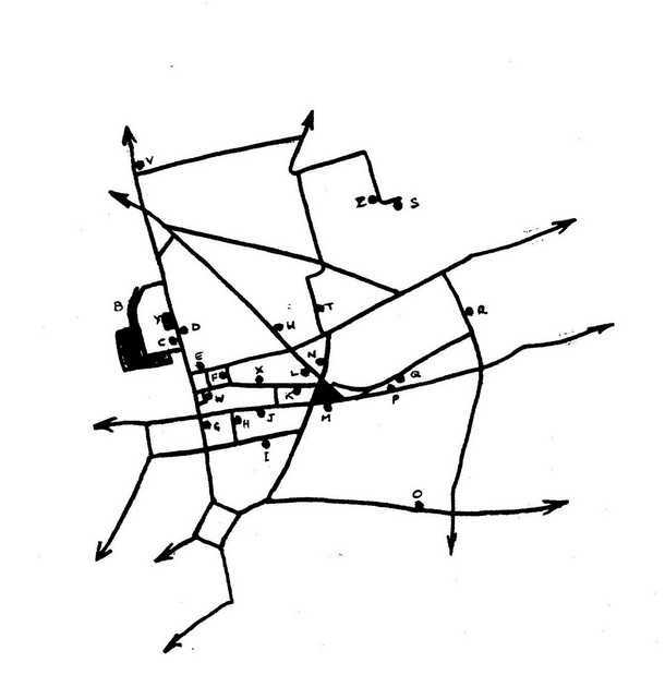
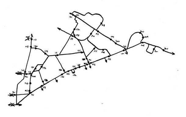
Part 1; Terminal Points in or near the City Centre:
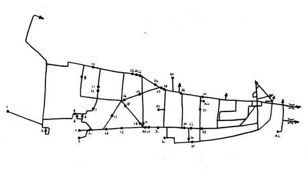
Part 2; Terminal Points in West Hull (Anlaby Road and Hessle Road)
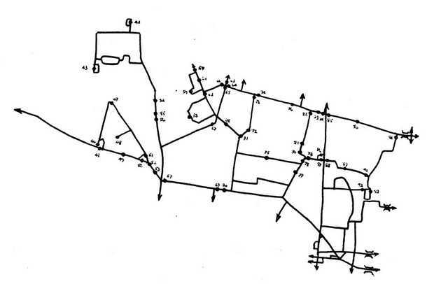
Part 3; Terminal Points in North-West Hull (Spring Bank West and Cottingham Road)
Part 4; Terminal Points in North Hull (North Hull Estate, Orchard Park and Bransholme)
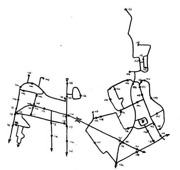
Part 5; Terminal Points in North East Hull (Saltshouse Road & Holderness Road)
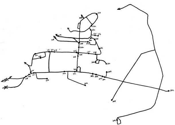
Part 6; Terminal Points in East Hull (Hedon Road, Bilton Grange & Greatfield)
Part 7; Unidentified Locations & Out of Area terminal Points. (Too large an area for a map)
Click here to view the seperate Index for Chapter Twenty Seven
Click here to view Appendix 1 - Appendix 2 - Appendix 3
This concludes the book on Kingston upon Hull Corporation tram, trolleybus and bus routes. May I extend my thanks to those people who have sent information, and corrections to the book over the past few months. It is my intention to produce a second edition, which includes the extra information.
If anyone has any further information or corrections I would be pleased to receive them, please send any items, in the first instance to the Old Bus Photos website for forwarding to me.
I trust that this book has been interesting and informative to others, and it is offered in the sincere hope that it fills a gap in information on this interesting operator.
Keith Easton, June, 2012.
04/06/12 - 17:28
Hi Keith
Can't believe you've actually finished this. One or two comments
When King Edward Street opened the northern tram routes alternated between there and Savile Street for a short time after protests from the latter's shopkeepers.
The Holderness Road terminus in Jameson Street lay between Savile Street and King Edward Street. the Hedon Road route terminated in Savile Street. the Pier route terminated in Queen Victoria Square outside the Dock Offices. For a short time in 1930/31 it terminated on the eastern side of Whitefriargate Bridge. It was extended to Paragon Station when the loop line opened in May 1914 but this did not last long. The TH cars may have also operated over this loop before the outbreak of the Great War but it did didn't last long, the TH being suspended for most of the war. The TH did run to the station from July 1923 to November 1923 but carried only about four or five passengers per journey.
The Holderness Road trolleybus terminus was moved the few yards from Hammonds to the stop near the Hull Daily Mail offices in March 1959 when the city centre re-routeing took place.
Malcolm J Wells
Comments regarding the above are more than welcome please get in touch via the 'Contact Page' or by email at
If you have a bus related article that you would like to appear on this site please get in touch via the 'Contact Page' or by email at
All rights to the design and layout of this website are reserved Old Bus Photos does not set or use Cookies but Google Analytics will set four see this
Old Bus Photos from Saturday 25th April 2009 to Thursday 25th April 2024